Oh, how I wish this was solely about geography. The Continental Divide is so much simpler, the Snow Dome so much more interesting.
But, no. We’re going to talk about political divides. Even … gasp! … intelligence divides. (Yes, there are some blatantly stupid people in this province, sometimes wilfully.)
As you might know already, we just had a referendum. It’s not quite over – it’s taken nearly a week to count all the ballots (such a colossal waste of money to determine absolutely nothing), and the official count isn’t released until next week, but we’ve got enough of a count to determine just where the problems lie.
Well, lie beyond the Government, which is our Principal Liar in all of this nightmare. But there’s a lot of people – far too many – who’ve taken the government’s word at face value. Sigh.
I took all of the voting data and applied it to our electoral divisions. Maps, ladies and gents! Things that make it so much easier to see!
Well, sort of. First things first, folks. Let us recognize a principal fact: land does not vote, people do. Just because an area is larger than another doesn’t mean there’s more people – in fact, the electoral divisions are created to have roughly the same number, no matter where they are. Which is why there’s more divisions within cities like Edmonton and Calgary. There’s 8 divisions that cover the northern half of the province by area; there’s 45 needed for Calgary and Edmonton (combined).
We past that? Size matters not? Good, moving on…
Here’s where the questions get fun again. I’m going to display all the maps – IN ORDER – so you can visibly see how this bullshit went down. I’ll link the SVGs so you can see them in their massive glory, too.
The maps are colour-coded: YES is blue, NO is red, and there’s a gradient between them. 50%, for example, is purple. The bluer an area is, the stupidier the people who live there (generally, there will always be exceptions).
The exception is Question 10, where REMAIN is blue and LEAVE is red. In that case, we’re letting blue folks be the smart ones.
The maps are all set up the same: full province on the left, Edmonton and Calgary in the middle, with Grand Prairie, Red Deer, and Lethbridge on the right.
| Question | Map |
|---|---|
| 1. Do you support the Government of Alberta taking increased control over immigration for the purposes of decreasing immigration to more sustainable levels, prioritizing economic migration and giving Albertans first priority on new employment opportunities? | 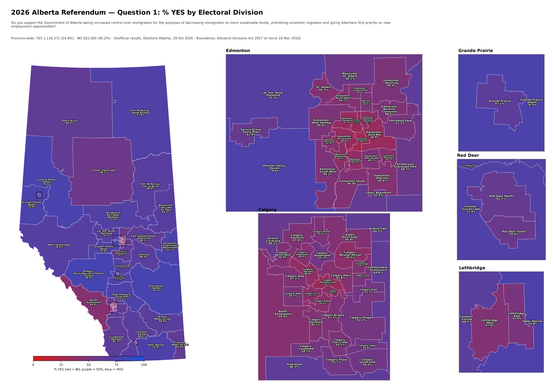 |
| 2. Do you support the Government of Alberta introducing a law mandating that only Canadian citizens, permanent residents and individuals with an Alberta-approved immigration status will be eligible for provincially-funded programs, such as health care, education and other social services? | 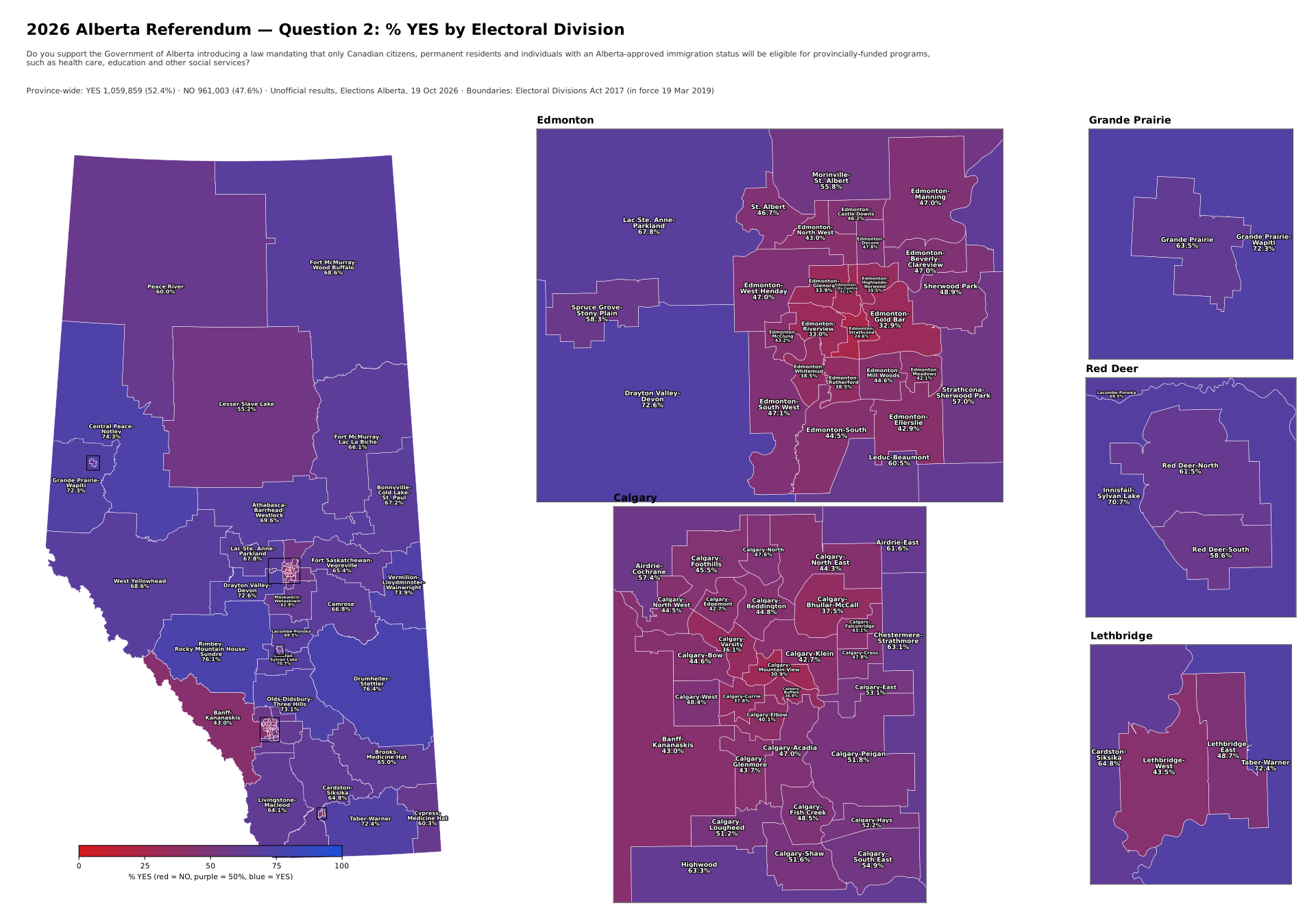 |
| 3. Assuming that all Canadian citizens and permanent residents continue to qualify for social support programs as they do now, do you support the Government of Alberta introducing a law requiring all individuals with a non-permanent legal immigration status to reside in Alberta for at least 12 months before qualifying for any provincially-funded social support programs? | 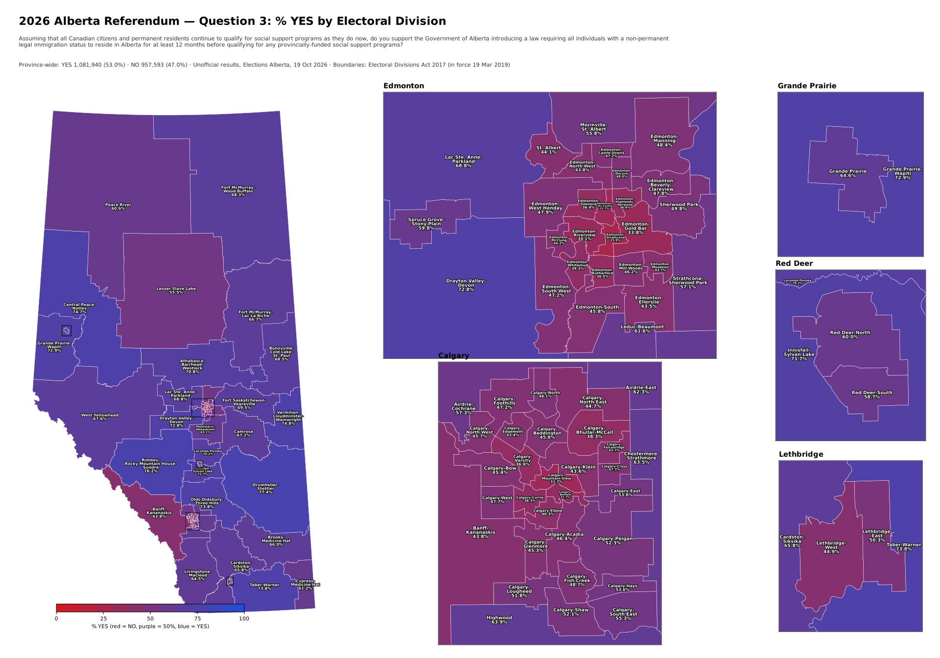 |
| 4. Assuming that all Canadian citizens and permanent residents continue to qualify for public health care and education as they do now, do you support the Government of Alberta charging a reasonable fee or premium to individuals with a non-permanent immigration status living in Alberta for their and their family’s use of the health care and education systems? | 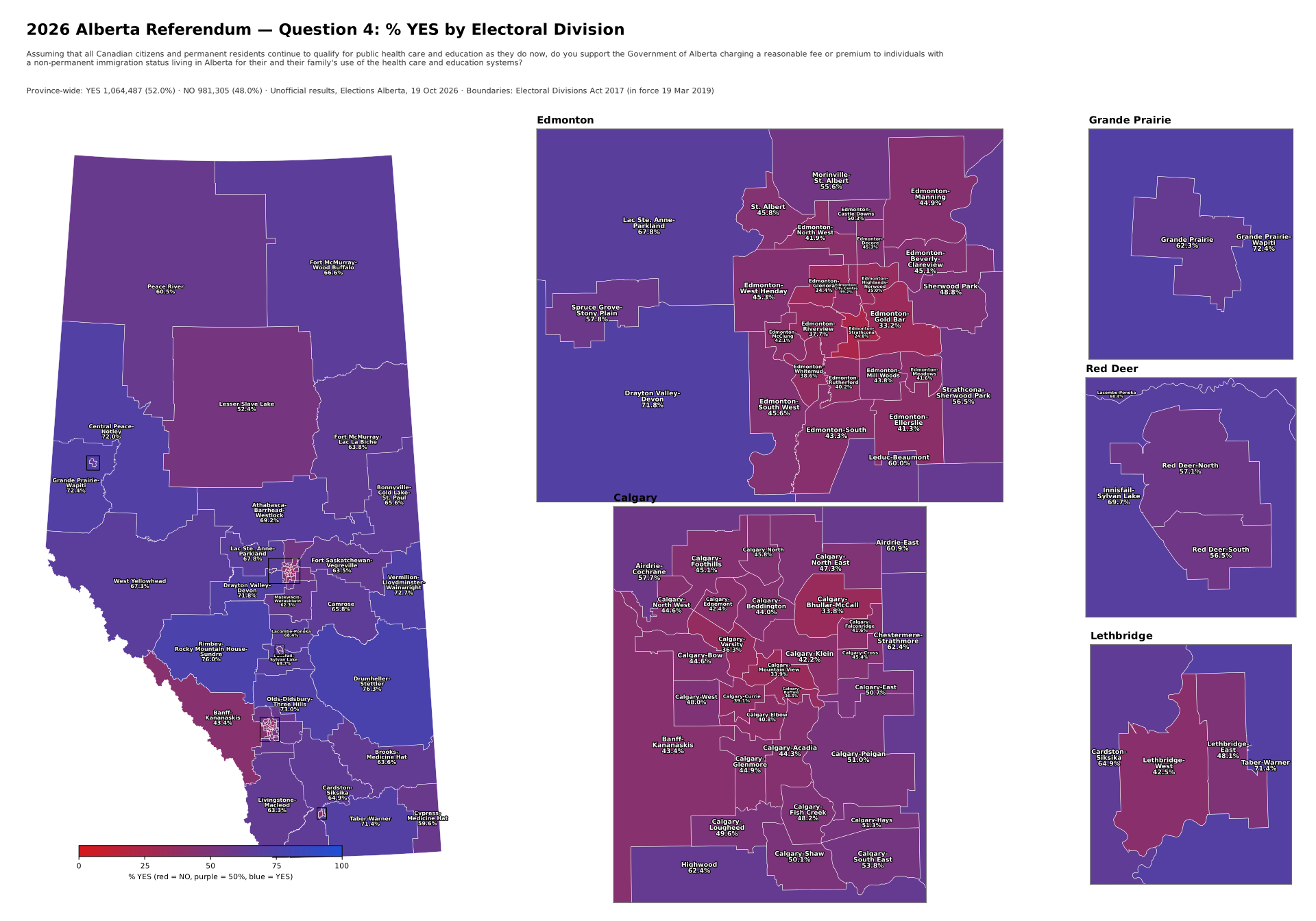 |
| 5. Do you support the Government of Alberta introducing a law requiring individuals to provide proof of citizenship, such as a passport, birth certificate or citizenship card, to vote in an Alberta provincial election? | 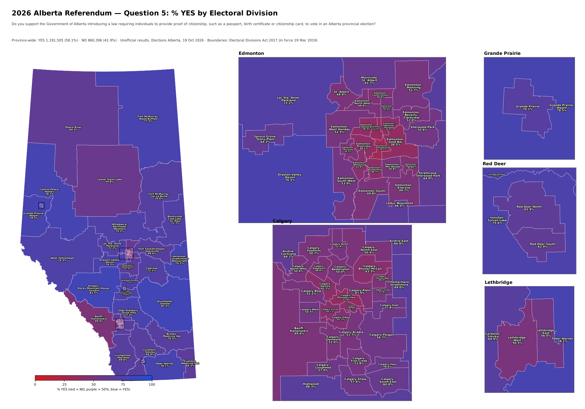 |
| 6. Do you support the Government of Alberta working with the governments of other willing provinces to amend the Canadian Constitution to have provincial governments, and not the federal government, select the justices appointed to provincial King’s Bench and Appeal courts? | 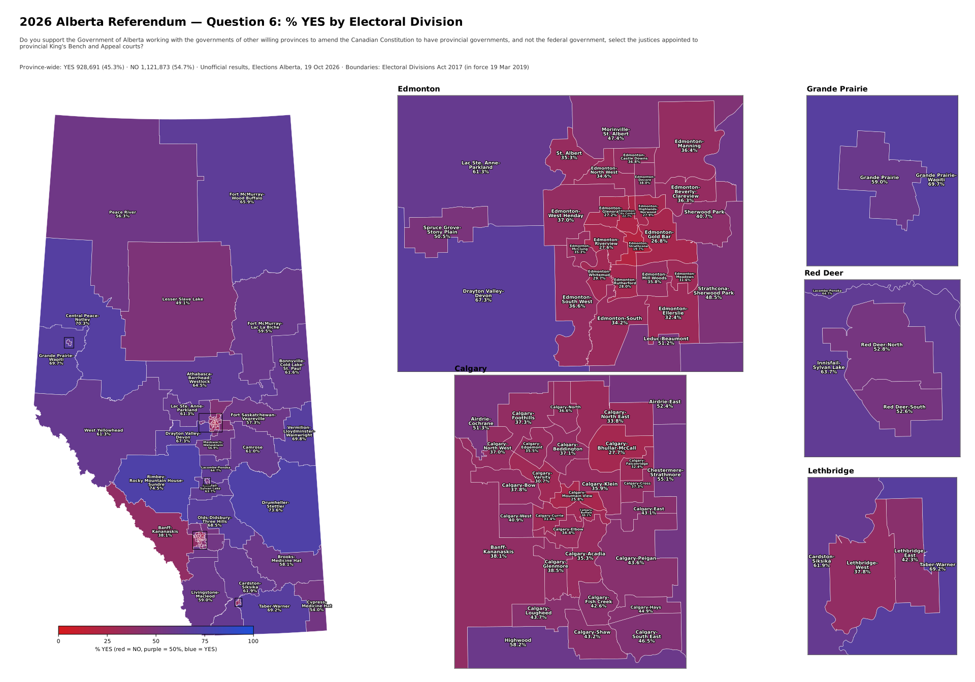 |
| 7. Do you support the Government of Alberta working with the governments of other willing provinces to amend the Canadian Constitution to abolish the unelected federal Senate? | 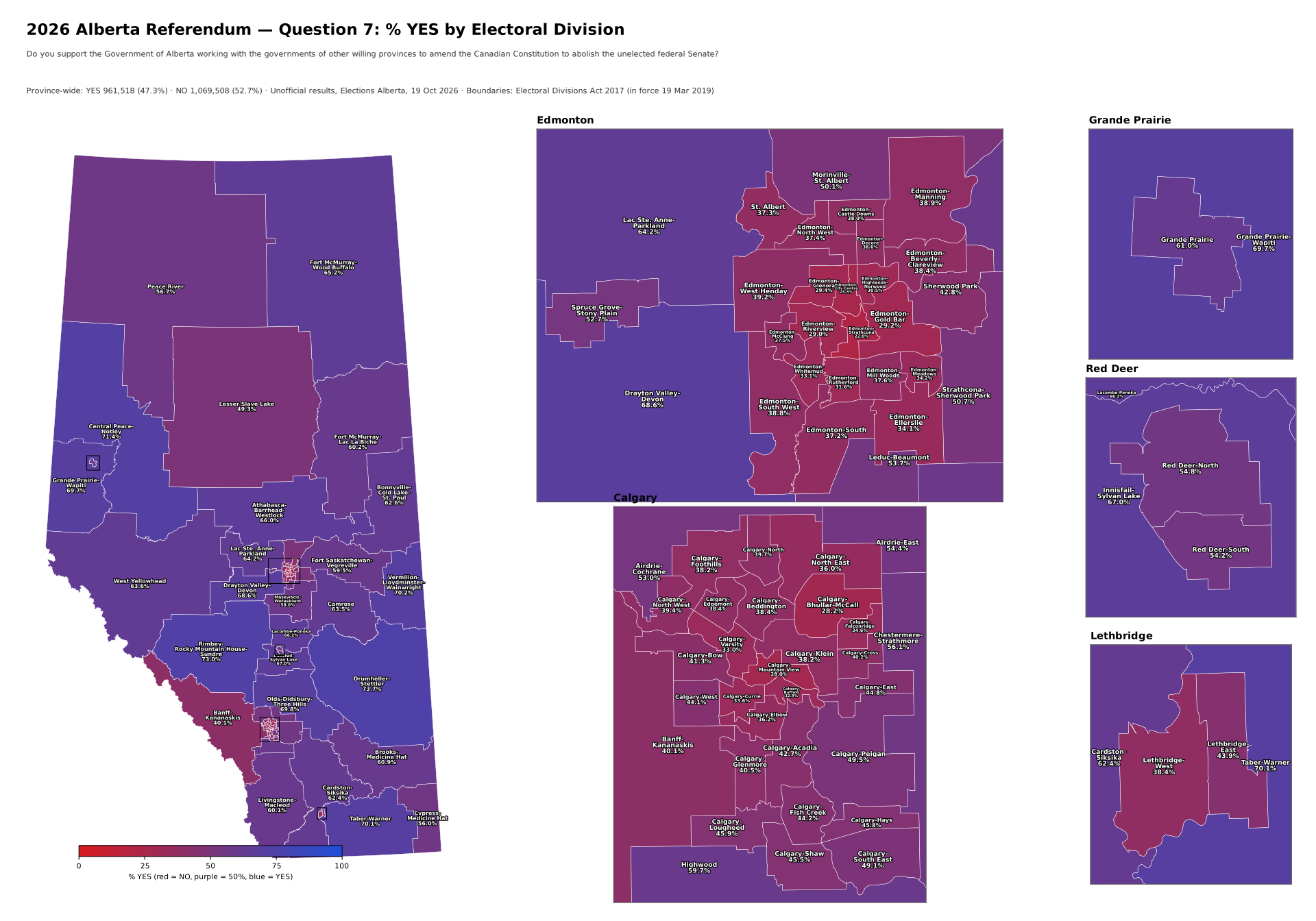 |
| 8. Do you support the Government of Alberta working with the governments of other willing provinces to amend the Canadian Constitution to allow provinces to opt out of federal programs that intrude on provincial jurisdiction such as health care, education and social services, without a province losing any of the associated federal funding for use in its social programs? | 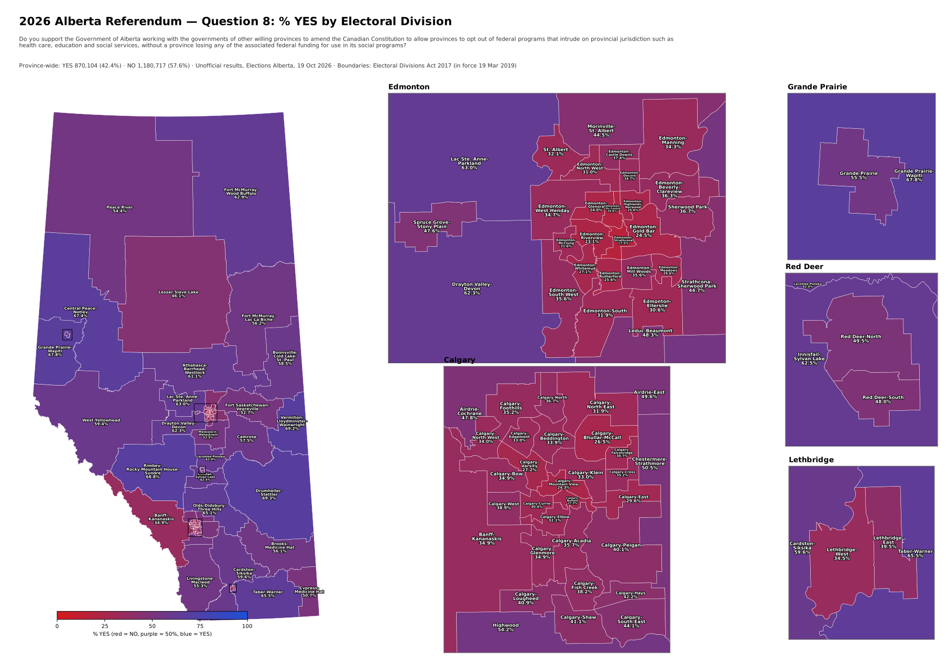 |
| 9. Do you support the Government of Alberta working with the governments of other willing provinces to amend the Canadian Constitution to better protect provincial rights from federal interference by giving a province’s laws dealing with provincial or shared areas of constitutional jurisdiction priority over federal laws when the province’s laws and federal laws conflict? | 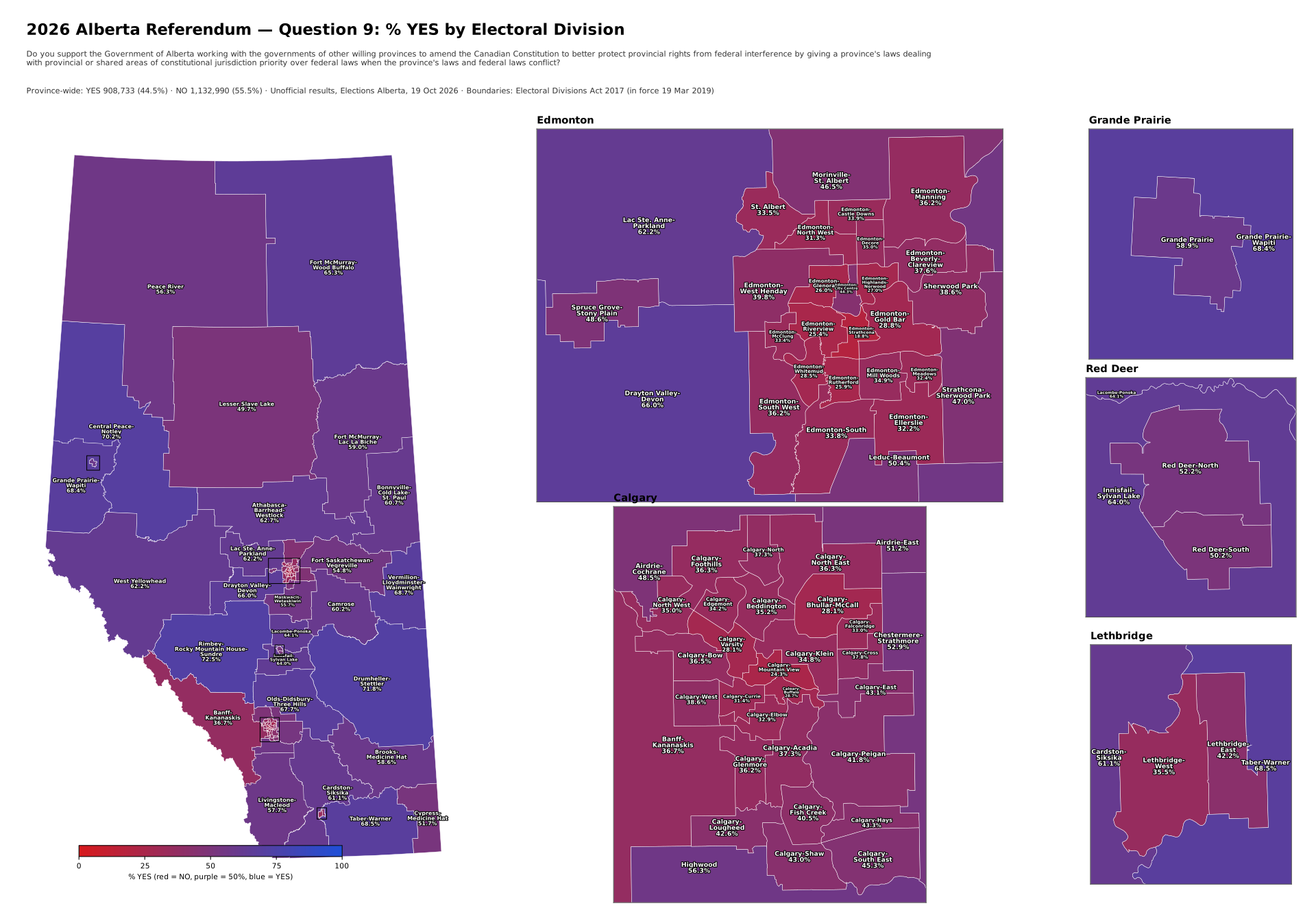 |
| 10. Should Alberta remain a province of Canada, or should the Government of Alberta commence the legal process required under the Canadian Constitution to hold a binding provincial referendum on whether or not Alberta should separate from Canada? Option 1: Stay. Option 2: Leave. | 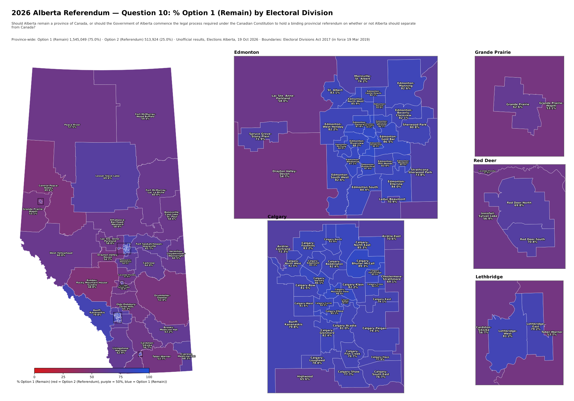 |
The advantage of seeing a visualization of this is that you can see how horribly racist our province is. I would love to say “has become”, but sadly, I think this has been lingering for a long time and the referendum just shone a light on it.
Questions 1-5 are shifted much more blue. Those are the racist areas of the province. And as much as I would love to say that the cities are the exception, they’re not. Edmonton and Calgary both have areas that went well into the racist side in Questions 1-5, showing a serious disdain for immigrants (strangely in the immigrant-populated Northeast Calgary; you assholes in the south side of Calgary can keep going south and don’t stop until you hit the “Gulf of America”).
Drumheller-Stettler, I think y’all need to take a very close look in the mirror. Don’t tell me that’s all farmers, there’s a large population sitting in your urban areas … the same urban areas that depend on tourists to bring in dollars to your region. Maybe you should pay really close attention to how you’re coming across, ‘cuz if I had actual skin colour, I would seriously think twice about visiting. (Hell, I’m seriously thinking twice, as a pasty white guy. You people make me genuinely sick.) You, too, West Yellowhead, home of Jasper.
Rimbey-Rocky Mountain House-Sundre – honestly, what the fuck is wrong with you?
Questions 6-9 are much redder. I’m not going to say that logic was more prevalent, because the bulk of the realization came from the major urban centres of Calgary and Edmonton, with support from Banff-Kananaskis and Lethbridge West. The rest of the province seemed pretty content to pick their noses with their middle fingers and think the Government was doing a good job.
Question 10 is very blue. That’s 75% of the population speaking, though there are still areas where leaving was seen as a better option. Again, the very far south awaits for you, don’t let the border crossing hit you on the ass on the way out.
These maps make it even more clear to me: I don’t want to be in this province anymore.