Morning began almost the same as Colorado Springs: cool and bright. But our distance south had provided us with a few degrees more warmth, making the morning not quite as shocking as the day before. Something else was different — no humidity on the walls. Once again Dhar was the first to rise, followed by myself, Stefan, and eventually, Rebecca.
I got my first good look at the camp that morning. It looked smaller than the one in Colorado Springs, but then again Cortez wasn’t exactly the place to travel (or at least so I thought when I first got up that morning). Under the navigator’s windshield wiper was a small piece of paper, left by the camp management. It was a reminder to check in at the office that morning. It was the first and last such reminder we saw staying at the KOAs.
There’s something about waking up at Cortez that I never really could quite comprehend. Cortez is mostly a flat plain, wedged between a few mountain ranges quite some distance apart. A few mesas interrupt the vastness, but not so much that it’s disturbing. Morning there is extremely peaceful. There’s no highway, no clamouring industry, no planes. It’s quiet. It’s slow. It’s too bad we couldn’t have spent the day there relaxing. But we had things to do, places to see.
Showers were the first order of the day. The stalls were much better than the ones in Colorado Springs, as we now had two taps to control the water’s temperature. I hastened back to the van to get dressed and prepare for the drive out to the Grand Canyon, as that was the primary goal of the day. Secondary to that was a stop at Four Corners.
Stefan arrived a moment later, allowing Rebecca to go and have her shower. Stefan quickly gathered up his wallet-pouch and headed over to the office to clear up any issues with our late check-in. I sauntered into the office a few minutes later and looked over some of the things they had in the store. I purchased more postcards and stamps while Stefan got the bill straightened out.
No sooner had I stepped up to pay for my purchases than Stefan announced we had a change in plans for the day. My immediate reaction was one of annoyance, since he had not discussed this change with anyone so far. He quickly clarified himself by asking if I’d ever heard of Mesa Verde, to which I responded I had. He then informed me that it was about 10 miles away from our camp. I suddenly realized two things: 1) Why there was a KOA in Cortez, and 2) We were going to be late getting to the Grand Canyon.
We informed Rebecca and Dhar of the slight change in plans when we got back to the Behemoth. Fortunately, neither objected to the change, even though none of us really knew what we were getting ourselves in to. The van was disconnected from the water and electricity, the oil and fluids checked, and a couple water bottles filled. I then took my position behind the wheel and headed us back towards Highway 160. We turned right and headed east.
The trip was fairly short, we could see the mesas just to the south-east. We passed a sign indicating a radio frequency we could listen to park information on. The quality of the broadcast was horrible, but thankfully short, taking only about seven minutes to tell us all that we needed to know. It wasn’t long after the sign that the part entrance appeared.
The park entrance off Highway 160 was 26 miles from the Visitor’s Center, which was where we had to go before we could find out what it was that we had to see. For some reason, this was either the most direct (or the safest) route into the park. I found it hard to believe that it was shorter for us to drive to the park entrance from the KOA than to get into the park itself. After paying our five dollar (American) entrance fee, we entered the second harrowing drive in as many days.
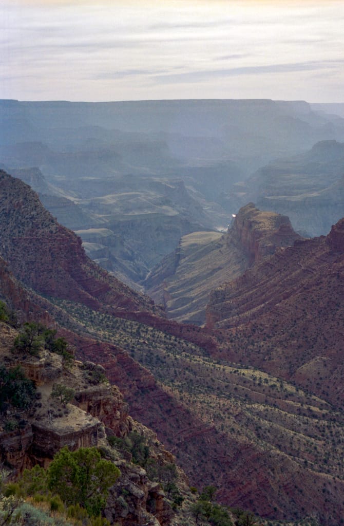
The park, like the structures it was designed to showcase and protect, was situated on the top of a huge mesa, over 750 feet above Highway 160. The road to get to that height had to bend around the edges of the mesa and slowly take us to the top. The views we saw were as beautiful as the ones we had seen the day before traveling through the mountain ranges. Only here we were treated to a completely different palette of colours: browns, reds, oranges, and greens. Off in the distance the Rockies were still visible, their white peaks reminding us of days past.
The route was lined with steep cliffs on one side and steep hills on the other. Although the speed limit was significantly higher than at Cave of the Winds, I chose to drive cautiously and not look over the edge unless we were stopped. This didn’t stop the others from peering out, oohing and ahhing, and telling me not too look. What I did keep an eye out for were the foxes, deer, and wild turkeys that were supposed to live in the area. (Although I didn’t want to hit a fox or a deer, a wild turkey would have made a great change in our dinner menu.)
About 45 minutes after entering the park, the Visitor’s Center came into view as we rounded a corner. It was an interesting structure: a two-storey circular building with a spiraling ramp around the outside. The building was on the left side of the road we were on, and the Visitor’s Center parking lot was on the right. The two were connected by a walkway underpass.
Upon entering the parking lot we saw our first vehicle from Canada, a beat-up orange Ford camper from Alberta. I wanted to find the drivers and swap stories, but we had no such luck. We wandered under the road and up the ramp on the other side. The building had a balcony that overlooked an area exceeding 5,000 square miles on a hazy day. (On a clear day, it was said you could see all the way to Phoenix, Arizona — about 300 miles away.)
But a clear day hadn’t been seen at the Visitor’s Center since the late 50’s. The sign told of a major problem that had befallen the area: air pollution. Although the nearest industrial centre was some 100 miles away, the problem had not gone unnoticed. Just southwest of the park I could see a long brown cloud. At first I had thought it might be a dust storm, the deserts and the wind in that region of the United States are known for dust storms. But after reading the sign, I knew that such a cloud could only be one thing: smog.
I have lived in a city all my life, I have seen pollution in many forms. In a way, I have come accustomed and maybe even immune to seeing it. Don’t get me wrong, I don’t like pollution — I’m all for different ways of getting rid of it safely. It’s just that if you stare at something long enough, you tend not to notice it as much. Toronto has a brownish haze to it for most of the summer months, and once in a while during the winter. Inside the city you’ll never notice a thing.
Outside the city my perspectives change, and where there are lots of trees, I expect clean fresh air. Colorado Springs had such air. But Mesa Verde is surrounded by nothingness for hundreds of miles. And yet the air pollution was worse than in an industrial centre. I wasn’t sure if I should weep for the environment, for our children, or for the Native Americans who had to live in that pollution. In a way the only winners are those who profit at the expense of everything and everyone else.
Inside the doors was a combination park information desk, bookstore, and museum. Two park rangers presided over the desk, providing information on the park and the tours, and taking fees for the guided tours. The park had three main sites open at the time we were there including two cliff dwellings and a small restored village.
Mesa Verde sound familiar yet? If the name doesn’t ring a bell, a picture of it would. Over two thousand years ago, a group of Indians called the Anasazi settled on Mesa Verde and began their culture here. Related to the Pueblo Indians, they brought the craft of building adobe huts for shelter with them. But out in the open, they found life very harsh. In an attempt to build villages that would withstand the often brutal environment, they built cities into the cliffs.
If you’ve ever seen a picture of a city built into the side of a small mountain, then you’ve most likely seen Cliff Palace, which is the largest cliff dwelling in Mesa Verde National Park. Because of its size and history, it’s also the only cliff dwelling in Mesa Verde that you can’t visit without a Park Ranger. Thus there is a cost for the tour, not only in cash, but in time — in excess of two hours. Cost for us wasn’t an issue (usually), but time was. We opted to do a self-guided tour of smaller dwellings.
After figuring out our plan of attack, we did a tour of the museum. Although small for a museum of Native Indians, the exhibits contained pottery, jewelry, clothes, and pictures of at least eight different tribes of Indians. Many of these things I had seen before in documentaries, National Geographic and other museums, so in truth, I wasn’t all that interested in them. I started to goad the others into hastier actions, since I wanted to get to the Grand Canyon before it got dark.
We got back in the van and drove further down the road we had traveled on. About seven or so miles down the road we arrived a parking lot surrounded by a gift shop and toilets on one side, and another museum on the other. All around us beyond the buildings were small trees, no greater than three metres tall. Unlike the deciduous trees further north, these had their leaves.
Mesa Verde must have received its name from these shrub-like trees. In English, Mesa Verde translates roughly to “green plateau”. Unlike the plains next to Highway 160, the ground on the mesa was completely covered in trees — you couldn’t see more than five metres into the forest.
We hopped out and began to figure out how to get down to the dwellings. We walked to the end of the parking lot (about twenty metres) and crossed over to the other side of the road next to another museum. There we quickly found more paths that seemed to lead into a small valley just beyond the museum. The trees continually blocked our view until we found a jutting of sedimentary rock upon which no tree grew. Climbing out on top of it, we caught our first glimpse of the dwellings on the opposite side of the valley.
As a kid, someone could have easily labeled me as a nerd (not to mention that someone still could) — I always read. The books I read were rarely fiction. I preferred the sort of books that explained the world around me. Not being religious, I received my explanations from scientific bases. National Geographic took me around the world, Time-Life taught me how the world was formed and why continents drift, and PBS showed me sights I never thought I’d see.
When I went to the Soviet Union in 1989, I saw things I had only heard of before and saw on the odd documentary or in a rare issue of National Geographic. I knew then that experience was no replacement for a facsimile. A picture may tell a thousand words, but an experience shows you the world. As with my first look at the Rocky Mountains, my initial glimpse of the dwellings was both exciting and awe-inspiring. And I was hungry for more.
The route to the dwellings took us down the one side of the valley (a drop of less than 150 feet), across the floor and slightly up the other side. Along the way were markers that indicated points of interest, listed on a small map Rebecca had picked up prior to us descending into the valley. The map showed different types of flora that grew in the valley, and places where the Anasazi had scraped out a living.
One of these places was at the apex of the valley, where a small spring was located. The spring formed when rain water and melting snow leaked through the rock and pooled. It was dry when we arrived, and I wondered if it had been wet any time in the past decade.
But it was the dwellings we had come to see. There was something almost magical about stepping near them, like the spirits of the past were watching us. They watched from the darkened windows, through deep doorways, and from the trees that grew behind us. Whether they were smiling upon us for remembering their history or passing a curse that would last for generations, we didn’t know.
The cave the dwellings were built into was roughly 150 metres long, 20 metres deep and about 30 metres high. The roof of the cave sloped down from the full height of 30 metres down to less than 10 at the rear. Rather, the rear that we could see. The dwellings were roped off in several strategic places to keep visitors from crawling all over the site. In the past this had been allowed, but assumedly over time things got damaged.
The dwellings were an impressive sight, if only from their history — the buildings were nearly 2,000 years old. According to the Park Ranger, the Anasazi abandoned the dwellings long before the Roman Empire crumbled. Yet here were structures as high as three stories, made of stone, mud, and cedar logs. The assemblage looked flimsy by appearance, but must have been very strong to have withstood the elements for so long with so little damage. The walls of the buildings ran from the cave floor to the cave ceiling, which must have provided a great deal of structural integrity. The cedar logs inside the towers must also have contributed to the longevity.
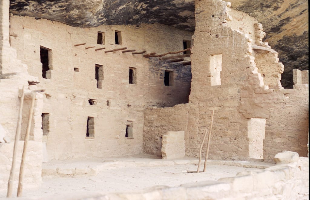
Just outside the cave were large holes, about 6 metres across and a just under three metres deep. At first I had no idea what they were, until I noticed a ladder seemingly coming out of the ground. The holes were ceremonial chambers (the name of which completely escapes me) that were dug into the ground then covered over with logs and flagstones. Small holes just outside the hole’s walls allowed air to enter the chamber and fan fires that burned inside.
For some reason, Stefan took objection to the Park Ranger’s explanation of the hole’s use as a ceremonial chamber. (I had not been aware that Queen’s Engineers were required to take anthropology courses. ) Stefan believed they were sweat houses, similar to the ones used by other tribes.
After touring the site for about half an hour, I started to goad the others into moving again. I wanted to make sure we’d get to our destinations while we still had light. A group of Native American schoolchildren who appeared to have come to the Park to learn about their heritage passed us as we slowly began to work our way back up the side of the valley.
The climb back up was much more difficult than it looked. I wasn’t sure my exhaustion was due to the altitude (hence, lack of oxygen) or my general physical shape (which I wasn’t in). Either way, I was fairly winded by the time we got back to the top. A woman in front of me didn’t even make it that far before she had to sit down to catch her breath.
Despite my goading, Rebecca ducked into the museum. We naturally followed to see what was there. The museum showcased some aspects of life the Visitor’s Center didn’t touch upon. Methods of weaving, how the cliff dwellings came into being, and general ways of life. A slide show in an adjacent room provided a more in depth view of Anasazi life, but we never got a chance to see it. Instead we browsed the museum’s gift shop.
Somewhere along the time we got briefly separated and we lost track of Rebecca. While Stefan and Dhar wandered up to the main gift shop, I waited in the van to make sure Rebecca wouldn’t walk by unnoticed. As it turned out, we men were blind and had missed Rebecca while she was in the museum. Soon we were all buckled in and heading back out towards Highway 160.
Observer’s Log: Traveldate 960424.1275
Day 4
Mesa Verde – a mystery? Many will speculate, but the truth will never be known – long drive to get there though. Next step is the 4 Corners, then (with any luck) the Grand Canyon.
We all agreed that the excursion had been worth it. None of us had seen anything like it before and I shuddered to think that I might not see anything like it again. To think that a people that every text lists as “primitive” could build such an impressive and enduring city is to not acknowledge the genius that was at work, and also to not acknowledge how far we haven’t come in those 1,000 years since the village was abandoned.
On the trip back, we were heading mostly downhill. The van handled moderately better than on the way up, but I was still a bit edgy. Somewhere on this trip down the van was named by a member of our group (though who it was I honestly don’t remember) — “The Behemoth”. The name seemed very appropriate: it handled like a dead mule, accelerated like a turtle on tranquilizers, and braked like a marble on a greased roadway down a hill. We could see over almost anything on the road except semi-trailers and cube vans. We could comfortably sleep four adults. This was no ordinary vehicle.
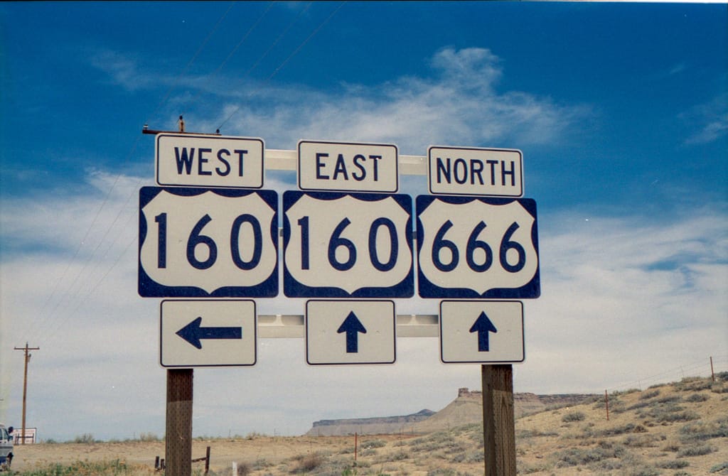
Upon reaching Highway 160, I turned left and headed back towards Cortez, where we would briefly link up with Highway 666 before heading southwest towards the Four Corners. The sound of The Beach Boys echoed through the van as we whipped through the downtown core of Cortez, a distance of about four miles. It wasn’t long before we were cruising down Highway 666 towards Shiprock, New Mexico.
Surprisingly enough, it took a while for someone else to notice what highway we were traveling on. It came as quite a surprise to the others that there was in fact a highway named “666”, especially when one considers that according to Christian doctrines, that’s the number of the Beast. But if there is a highway to hell, the Highway 666 is it. The south end of Colorado and well into New Mexico is barren — no trees, hardly any shrubs, no water, a few lonely mesas and hundreds of dry river beds.
Shiprock wasn’t our destination however, and we left Highway 666 about seven miles from the Colorado / New Mexico border to continue along Highway 160. But not before we pulled over to take a picture documenting to the Doubting Thomases back home that the Americans did in fact worship the Devil in some parts of the country.
By this time, we were well into Indian country. We entered the Ute Mountain Indian Reservation about 10 miles outside Cortez. When we entered Arizona we crossed into the Navajo Indian Reservation for some 200 miles of desolation, ending at the Kaibab National Forest.
It was the desolation that I found most intriguing. The American government had taken all the Native Indians and had placed them in this area of the United States. According to Rebecca, there had been a study published by the Government about the area several decades ago which claimed that the area was unsuitable for farming, fishing, raising cattle, industry, commerce, and living in general. On the top of the report there was the ink of a rubber stamp: Suitable for Indians. The truly depressing part is that it wasn’t an American government — it was Canadian. I didn’t want to know what the American governments had done.
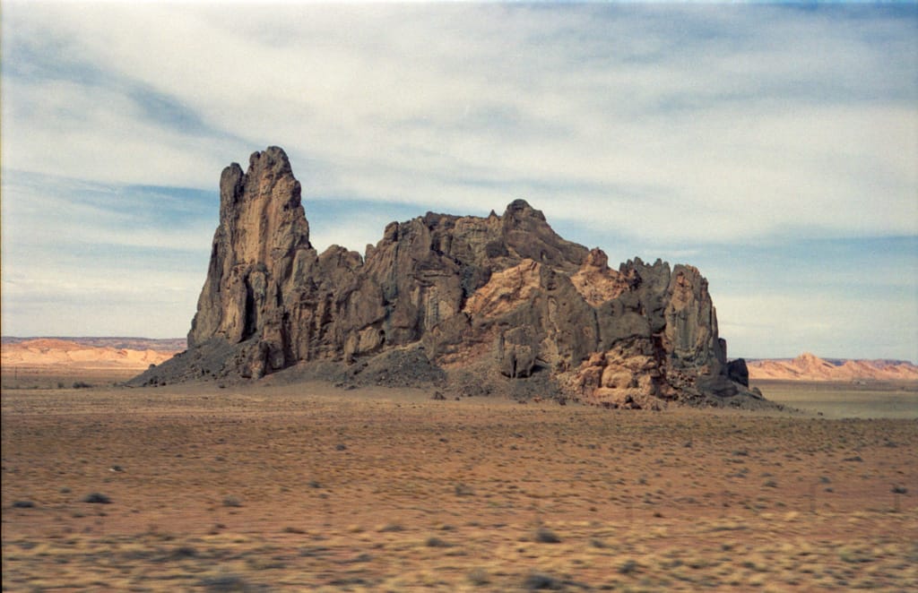
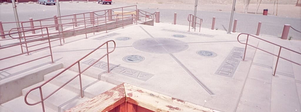
We didn’t come into contact with any Native Indians until we reached the Four Corners. The Four Corners is the only geographic / political location in the United States where four states touch at a common point. I always imagined that the four corners were marked by white chalk stones on the top of a grassy hill, kind of like the one featured in Coca-Cola commercials I had seen. But we were in an area that had no trees, let alone grass, and the only hills were steep-faced mesas.
Highway 160 briefly enters New Mexico before going into Arizona, it was from the New Mexico corner that we entered the site. Existing in designated Ute Indian territory, the Ute Indians managed the Four Corners allowing members of other tribes to enter and sell their wares to tourists. At first everyone was dismayed at the five dollar entry fee to look at some lines in the dirt. I was quick to point out however that Native Indians have always had a hard shake from the Government (United States or Canadian), never receiving true compensation for all that they have lost. As far as I was concerned, five dollars was a very reasonable price.
Four Corners is, to put it politely, a very basic tourist trap. The actual location of the four state corners (which, in all honesty, ain’t much to look at) is ringed by about 30 wooden stalls where Native Indians sell “authentic” Indian crafts and food. Quite often, so I’ve found in the past, many of the crafts are made in Taiwan, and the food comes from local 7-11s (though if there was a local 7-11 at Four Corners, someone went to great lengths to camouflage it). I didn’t go up to the stalls to verify my suspicions, so you may assume that I am incorrect in my beliefs.
The Four Corners is essentially a large light grey concrete square about six metres across, with two lines running diagonally forming an ‘X’ in the middle. At the apex of the ‘X’ is a large dark grey circle, about a metre in diametre. In each of the four triangles formed by the ‘X’ is the appropriate state’s name and seal. Tubular railing mounted all over the concrete platform ruined the site for me, there was no way to take a picture without getting at least ten metres of the stuff in the frame.
Rebecca took the opportunity to review the stalls, while Dhar and I remained in the centre of the roadway. Both of us felt guilty about walking by the stalls and not buying anything. I felt guilty in general about the treatment of Indians, both in the U.S. and in Canada. Alas, my personal beliefs are not shared by many. While I believe the Indians should be allowed to settle wherever they want, many people I’ve overheard in conversations go with more Darwinist tactics — we beat them, they deserve nothing. It’s that kind of attitude that causes strife in our world, and will eventually lead to the destruction of our civilization if left uncontrolled.
It was almost 14:00 when we boarded the van once more, this time with Rebecca at the helm, for our long drive across the State of Arizona. It was over 200 miles to the Grand Canyon, and would take us just over three hours to get there. The worst part of the ordeal was that the temperature kept rising as we drove, and the air conditioner had been left off to conserve gasoline.
The terrain, despite its given name of “Colorado Plateau”, was full of hills and valleys. The cruise control on the van continually shifted in and out of the overdrive to deal with the rises and falls. Several times we had to turn the cruise control off as we drove just keep the engine from sounding like it was going to burst from its housing. I shudder think what the engine would have sounded like with the air conditioning on.
And I sometimes wished that the air conditioning was on. Less than a day before we were in the high teens for temperature, quite comfortable for those who had been in a long winter. But in Arizona those temperatures were easily doubled inside the van. Every window and vent that we could safely open blew and sucked warm air throughout the van. Rebecca took advantage of wearing her skirt by having the driver’s foot vent blow air right up her dress.
Observer’s Log: Supplementary
Arizona has one thing over Kansas – at least we can tell we’re actually getting somewhere. Kansas has one thing over Arizona – it’s much cooler. 80 degrees inside an enclosed space for four hours is going to hurt immensely. Rebecca got stuck with driving.We’re almost in the heart of the Navajo Indian Reservation. Have to feel sorry for them – there’s nothing here, not like there used to be when they lived in the Great Plains.
And I do mean nothing. The majority of things we saw out there was sand and sun. The only place more desolate than that would be either the Sahara Desert, or Antarctica — they receive about the same amount of precipitation and have about equal ability to sustain life. That part of Arizona wasn’t too far behind.
Only the movements of the mesa and rock formations told us that we were going anywhere. Kansas was too flat for any such markers. Once in a while we would spot a few Indians with their livestock, usually sheep or goats, grazing along the road on the wrong side of the fence.
We passed one rather interesting anomaly along our route. I don’t know what it was, but it was certainly strange. We passed under what looked like a covered conveyor belt, running from a mesa about a kilometre or so from the highway. It continued across the highway to a large structure I could only define as a holding tank. Alongside the building was a single-track railroad, with electrical lines running along the route.
Electric trains in North American are a rarity. Electric trains in the middle of Nowhere, Arizona are unheard of. Yet here was such a train. The tracks ran alongside the highway for about 50 miles or so before vanishing off into the distance. Not once did a train pass along the line, nor was there any signs indicating what it might be. Alas, it remains a mystery.
Not quite as much a mystery was another of Stefan’s annoying habits, though probably only annoying to me. Stefan’s father, aside from being a brilliant engineer, was also an accomplished musician. I’ve found that children of musicians seem to have a keen ear for how things should sound. Almost every time we put on a new CD to listen to, Stefan would jump to the equalizer on the van’s stereo and fiddle with the controls. Several times I was tempted to slap his hands and tell him to keep the hell away from it. But I couldn’t entirely blame him — I’ve been known to do the same thing.
This particular habit of Stefan’s was particularly common when he was navigator. One of the navigator’s duties, aside from figuring out where we were and which way we were supposed to travel, was put in new CDs every so often. And when Stefan was in charge of this, the equalizer controls were shifted. While this custom was annoying to me, I will grant that Stefan had a knack for making a mediocre CD playing on a portable CD player through a cassette deck adapter sound pretty damn good.
Music was one of the few things that kept us sane as we crossed over large expanses of land. The north-east corner of Arizona was just such a case. We made few stops while passing through Navajo country, one of them was in at the Tuba City Booger Thing. Sorry, Burger King. (I’ve never been too fond of that particular fast-food franchise, the food never really sat well with me. The only Burger King in Oakville died in 1990 or 1991, and was replaced with a Tim Horton’s. A much better choice, if you ask me.)
Everyone except me got something to eat. I wasn’t particularly hungry anyway, so I really didn’t care too much. Heat seldom makes me that hungry. Rebecca relinquished her driver’s position to Stefan. I took his place as navigator as we headed to the end of Highway 160 to pick up Highway 89. As Stefan drove, he continued to be amazed at how long we had been inside the Navajo Indian Reservation. I continued to be amazed at how dirty it was.
So far, all of our tours on the highways of American, Interstate or otherwise, had been very pleasant. Everything had been clean. Now whether it was the fact that Highway 160 went through the middle of Navajo country and thus was excluded from Federal or State Transportation Departments I don’t know. But what I do know is that there was more garbage along the sides of those highways than my family generates in a year. It was disheartening to see such neglect, but I didn’t know who to blame: the governments, the Indians, or the motorists. Well, obviously the motorists…
After leaving Highway 160 for Highway 89, we briefly headed south for 15 miles. We then resumed our westerly heading along Route 64, which took us into Kaibab National Forest, and eventually into the Grand Canyon National Park.
I don’t know if it was the lack of food, the dehydration, sleeplessness, or the heat, but I was getting irritable. Really irritable. The moment we saw a canyon, Stefan’s eyes started to frequently leave the road and look into parts of the Grand Canyon. To be blunt, this pissed me off. We came close to the edge of a canyon wall once or twice, but the fact that he didn’t watch the road while we were driving was getting on my nerves. Several times I came close to telling him to pull the van over so I could drive. But before I worked up enough gumption to become a complete asshole, we entered more trees and Stefan was forced to return to the major job of driving.
After paying a $7 entrance fee (valid for seven days), we proceeded to the first stop within the Park, known as the Watchtower. We could see the tower when we pulled in, but we didn’t proceed to it just yet, as we had other things to do first. Among them was a trip to the toilet, a tour through the first of two gift shops, and a call home.
The Grand Canyon hardly had any visible signs of native animals, the only animals we saw were ravens. These were huge birds, about the size of a small turkey. They hopped around the picnic areas like the seagulls and terns we’re accustomed to back home. Dhar and I were a little surprised at the enormity of the birds, seemingly almost mutant.
One of the gift shops was near to where we parked, and was one of our stops. I just knew that a gift shop in America’s best known natural wonder was going to have some of the gaudiest souvenirs ever concocted by man. I was not disappointed. I won’t tell you all that I saw, but there were t-shirts, hats, posters, cacti, and bandannas. Any place selling bandannas should be avoided. That’s not to say that places selling wall clocks made from slices of tree trunks, or cow dung for that matter, are any better.
Outside the store was a phone, which Stefan and Rebecca made use of to contact their kids back home. Eric was loving the vacation from his end of the phone, because it meant that he didn’t have to go to school. Staying with the grandparents meant that he was too far from school to be taken in every day. I felt sorry for Stefan’s parents (who were minding the kids), I knew from first-hand experience just how hard it was to keep Eric calm for a mere five minutes, let alone 12 days.
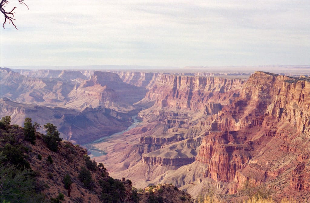
It was just after 18:00 in the afternoon when I finally got my first look at the Grand Canyon. We walked down a path away from both the parking lot and the gift shop, heading approximately north. Even though we were still a hundred metres from the edge of the gorge, we could already see the splendour that attracted tourists from around the world. It was yet another visual feast for the senses.
Having formed from hundreds of millions of years of sedimentary rock, then millions more years of erosion from wind and water, the Grand Canyon is named as well as the English language can suffice. There is no equal to the intricacies and the blatant beauty of the canyon, nor is there a succinct enough word or phrase that can accurately describe it. Although I don’t know what the phrasing would be, the Native Indians probably have a word or a name in their languages that describes the Grand Canyon much better.
The ochre and pale orange rock glowed in the setting sun, the entire valley looked like a giant ember from a dying fire. You could follow hundreds of layers of rock to the bottom of the canyon, where the deep turbulent blue of the Colorado River cooled the intensity of the view. By the time we reached the Watchtower’s position, we could see for what seemed a hundred miles north and east. Trees blocked our view to the south, and heavy haze shielded our glance to the west. Yet even that haze cast a heavenly glow about the deep ‘V’ in the Earth, as if carved by the hands of gods.
We basked in the warmth of the view and struggled in the stiff wind that blew through the canyon, taking several pictures of a sight I’ll probably not see for some time, if ever again. But soon curiousity won over my Grand experience, and I decided that a review of the Watchtower was in order. This started with a quick look at a plaque placed just in front of it.
Built in the early 1930’s, the Watchtower had been designed by early tour operators to provide an excellent view of the Grand Canyon. The Watchtower was built from rocks local to the area, and from nearby trees. The Watchtower was built in two parts: the base section and the tower itself. The construction of the base was similar in nature to the ceremonial pits we had seen at Mesa Verde earlier in the day — circular in formation, with long wood logs creating short arcs around the walls forming a partial dome upon which the roof was constructed.
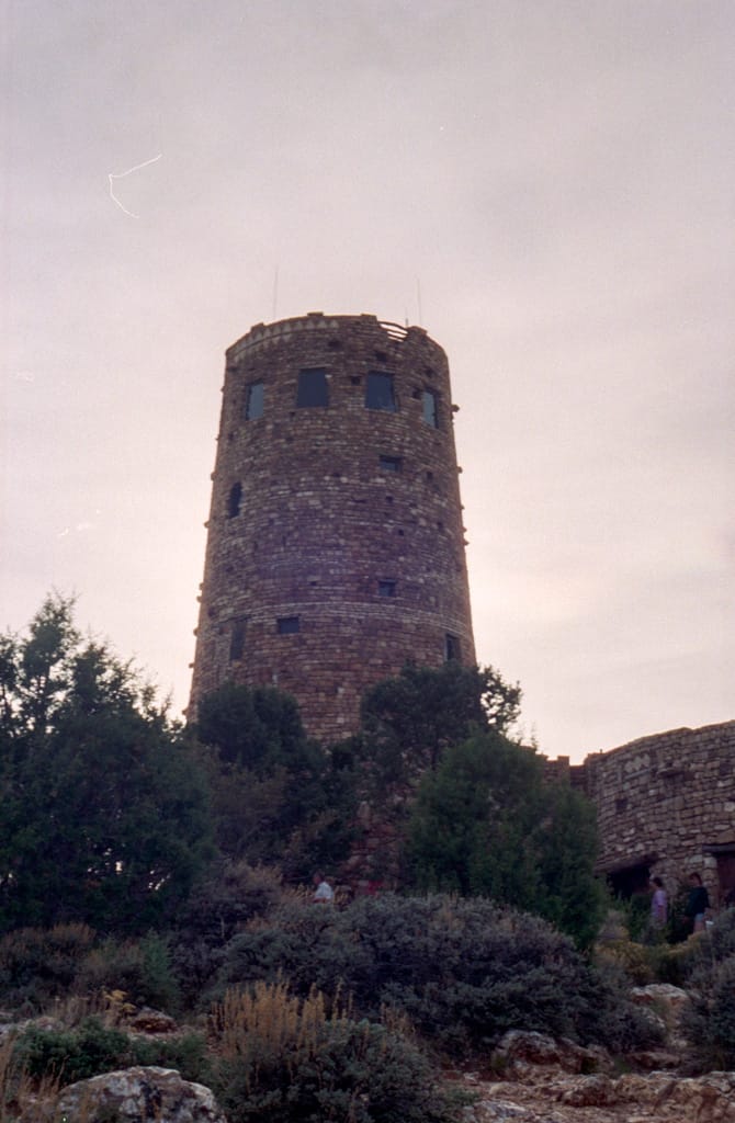
The room was almost perfectly circular, except for the side the tower was attached to. There the circle had a squarish protrusion. The base functioned almost entirely as a gift shop. The majority of the items in the store were much more appropriate for such a venue, not at all like the things at the gift shop at the parking lot. The squarish protrusion contained mostly t-shirts.
The tower was accessed by a set of curving stairs from the base, guarded by a turnstile that cost a quarter to use. Unlike the phones in Colorado Springs, the turnstile took a Canadian quarter, which unfortunately was the only quarter I had at the time. (I swear it!)
These stairs took you to the first level of the tower which contained a circular display case in the middle, and a Native Indian fresco on the wall opposite to the stairway leading to the base. Near the stairway was a door that led to an observation level on the base’s roof. The fresco was mostly red and brown with some white. Dhar and I took pictures of the fresco, but due to misreading my light levels, my picture of the fresco was far too dark.
Another staircase led you up to the second level of the tower, which contained only a couple benches and some small windows. This level was essentially a ring around the inside of the tower, the centre looked down into the first level of the tower. Another set of stairs led to the third and last level of the tower.
The windows on the third level were much more open to viewing than the ones on lower levels. Coin-operated telescopes allowed a more close-up view of parts of the canyon. Signs on the wall gave instructions to camera users on how to obtain zoom shots with the use of the canyons. Dhar fed a quarter into one of the telescopes and immediately decided that using the telescope as a zoom lens was not a good idea. I concluded the same after a quick peek.
To this point in the trip, I had not succumbed to any tourist purchases except for the postcards. But one of the shirts on sale in the squarish protrusion in the base appealed to me. It was a dark olive colour with faint Navajo patterns. On the left breast was a small gold phoenix with the words “Grand Canyon” under the logo. I also took the opportunity to buy more film. I had meant to buy some earlier in the day, when we were at Mesa Verde, but the prices there had been completely outrageous. On future trips, I’m buying all my film in advance…
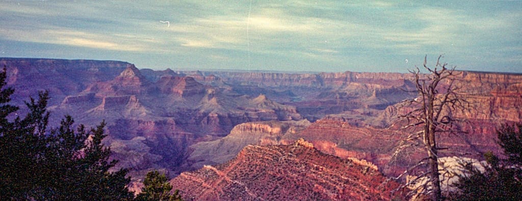
I coaxed the others to proceed further down the road to another point about ten miles away so I could get a different view of the Canyon. Unfortunately, time wasn’t on our side and in a few minutes we would be without enough sunlight for my panoramic camera to work properly. Disposable cameras are fun and easy to use … but only when there’s bright sunlight around.
Like the rest of Route 64, the road was usually bordered by trees on either side within the park, a calming kind of scenery. Yet the experience of driving down the side of a huge gash in the ground bordered by lush trees in the middle of a desert, listening to the Bee Gee’s “Stayin’ Alive” was enough to strike a feeling of insanity in the sanest of people. Of course, I’m not about to vouch for the sanity of Dhar, Rebecca, or Stefan — I already know I was a lost cause.
By the time we reached the next point, sunlight was questionable. Nevertheless I took the opportunity to try and take a couple pictures. I wandered around the guardrails (as many people frequently did) and went down about 80 feet into the canyon. From there I had an unobstructed view of the gorge’s walls. It was to be the last picture I would take, as the light levels quickly shrank away after that. Several people from Spain or Portugal (I couldn’t quite tell which) continued to take pictures of their group as I proceeded back up to the main tourist landing.
There I found another sign, containing the history of a hotel that had once been in service in the park. On the opposite side was the history of a copper mine that had flourished for a brief period on the canyon floor. Both were built prior to the Depression, which quickly put an end to both ventures despite the popularity and profitability.
The sun was disappearing fast, but our hunger was not. I hadn’t eaten since that morning (and even then I think all I ate was an orange), and Stefan’s lunch hadn’t kept him full for long. On a suggestion (from someone) we decided to stop at the Park’s picnic area and make our dinner. We had been keeping our chicken breasts thawed for just such an occasion. That night we would feast upon fajitas, vacation-style.
We drove further west along the road until we reached the park headquarters where the campgrounds were located. Here Highway 180 started and joined with Route 64 (less formally known as the park road), beginning its trip south towards I-40, our eventual destination.
We pulled into a spot and set about digging out the barbeque and propane tank. The signs indicated that we were only allowed to cook at the fireplaces provided. But the fireplaces required charcoal, which we didn’t have. I assumed the signs were to prevent campfires, but decided to avoid a nasty situation and placed the barbeque on top of the fireplace grill. It was a bit of an awkward fit, but it worked.
About that point another van arrived in the parking lot. It was our mysterious friend from Alberta. I stood beside myself for a moment, wondering at the odds that we would see the same van twice in the same day, almost 300 miles from place to place. The temptation to wander over and meet our fellow countrymen was overwhelming. Hunger, however, won.
By the time the green peppers halves and the chicken hit the grille, the sun had effectively set and darkness set in. The fact that we were eating in a forest didn’t help matters any — what little light that was left didn’t diffuse through the trees easily. Camp candles refused to stay lit for long in the night breeze no matter how much we tried to shield and re-light them.
This caused a minor problem at the picnic table — we couldn’t see what we were eating. Before we had left home, my father had suggested that we take a flashlight. My mother had suggested that we take a huge camping light that used one of those heavy 12 volt batteries. I suggested the Snakelight instead. Black & Decker can make a pretty good product, and the Snakelight is one of them. It’s not very powerful, you don’t have a bright narrow beam, but when wrapped around the trunk of a thin tree, it provides a dandy glow for having dinner. Black & Decker should talk with MAG and create a hybrid Snakelight / MAG Light. Now there’s a product!
The fajitas were just what I needed — I felt a whole lot better once I had finished. By the time I had eaten my last bite, the chicken was chilled and the peppers were polar … but tasty nonetheless. We then set about the quick task of cleaning up. Unlike several of our evening meals, we actually washed the dishes before leaving. (As the trip drew on, we got into the habit of leaving them out for longer periods of time. Hey — we were on vacation. Who wants to do housework on vacation?)
Following a stop at the washrooms, we headed out to Highway 180 and began our hour long trip to the I-40. Dhar took control of the wheel, I resumed my position as navigator, Rebecca and Stefan took their place in bed.
On exiting the Grand Canyon National Park, the theme for the trip was finally established through a collective effort: “Been there, done that … next!” This theme was appropriate for many reasons, though the primary one for us was in how the trip was being executed. We were going to some of the most spectacular sights in the Mid and Southwest, stopping briefly, taking in the view, and then heading to the next sight. After a while I started to feel like Chevy Chase in National Lampoon’s Vacation when he and the family stop briefly at the Grand Canyon on the way to Wally World.
The trip down Highway 180 / Route 64 was uneventful. The view was darker than a black hole, broken only periodically by the piercing headlights of oncoming traffic. Once we exited Kaibab National Forest (which surrounded Grand Canyon National Park on the north and south sides of the Canyon), signs of civilization began to appear, including an IMAX theatre. When Highway 180 veered off to the southeast shortly after exiting the forest, we continued south on Route 64.
Our gas supply was beginning to run low. The van had a tendency to go through the tank at an increasing rate from the time it was filled — the needle would drop very slowly at first, dropping quicker as the tank emptied. Typically when the tank reached a quarter full, we would start to look for a place to fill up.
We reached Williams, Arizona about a half hour after leaving Highway 180. Gas prices had mysteriously risen to $1.35 a gallon. Until then, we had been paying $1.20 or less for gasoline, and were not exactly in the mood to be paying so much extra. Dhar and I made the decision to continue west along the I-40 to Ash Fork, where we hoped cheaper fuel could be found.
But the gods weren’t with us that day. In fact, we had finally hit the first signs of bad timing of the entire trip. Unbeknownst to us, gas prices had started to climb dramatically in the United States. In Canada, fluctuations of as much as 10 cents were commonplace, and although a nuisance, were grudgingly accepted. A rise of a mere five cents in America is enough to get politicians voted out of office. Our poor timing was to land in the middle of these price hikes. The further west we traveled, the more expensive the gas became.
We filled up at $1.37, and chose not to argue any further about the price. But even that would get us only as far as Kingman, Arizona before another fill-up would be needed. It was already 20:00, and we had five hours of driving to reach Las Vegas. A late entry to the KOA was going to be unavoidable.
The speed limit across most of the I-40 was 75 miles per hour, a speed that none of us were too comfortable with the Behemoth. Unfortunately, the semi-trucks passing us at 85 miles per hour didn’t seem to mind so much. Such passings regularly spooked Dhar and I, keeping us awake for quite some time.
Arizona is a sparsely populated state, as is Utah, New Mexico, and Nevada, Arizona’s neighbouring states. This sparse population leads to one beautiful thing about the night in that area of America — light pollution is not a concern. Several observatories are built in that area to take advantage of the lack of light. The lack of light also allows one to see lights from a great distance. Even at almost 200 miles distance, we could soon see the bright lights of Las Vegas as a faint glow in the sky. At first I thought it to be a nearby city, but we never passed the glow as we continued westward.
Dhar tired quickly, driving for only an hour and a half before I took over. Rebecca took sole possession of the rear bunk as Stefan came up to join me, forcing Dhar to camp out in the lowered section of the floor (which was coincidentally just long enough for someone to lie down). There were a couple disadvantages to staying there while the Behemoth was in motion — the friction of the drive shaft caused the floor to become very warm, and the floor wasn’t sound proofed. Nor was it terribly comfortable.
It was roughly 00:30 when we reached Kingman, the last major city in Arizona before hitting Nevada or California. Just outside of the city we filled up with increasingly expensive gas before making our punch into Nevada. Already the glow of Las Vegas was plain as the moon in a cloudless sky. There was a dusting of clouds that night though, which was the only way we could really see most of the lights. I have to wonder if any resident of Las Vegas has ever seen a starry sky.
We left I-40 for Highway 93, which ran from Kingman directly to the Hoover Dam and Las Vegas. Highway 93 was barren — no trees and hardly anything to see within 100 metres of the road. But the further we drove up it, the more defined the lights in the sky became. In particular, the lights of the Luxor Grand Hotel and Casino. It was one of the new breed of resort hotels, designed to look like a gigantic pyramid. At the peak was a transparent cap, through which shone a 40 billion candlepower light. (Yes, you read correctly, 40 billion. With a ‘B’.)This light was so bright it could be seen from space on its own. In theory, you could cook a hot dog over it. And a bright spot in the massive glowing mass in the sky indicated where the Luxor lay.
Stefan wanted to see those lights badly. I guess the desire was the result of being such an engineer. I was curious too, mind you — I had taken apart and assembled enough things in my day to be curious enough to wonder how most things worked. The lights themselves weren’t a mystery — how they got so bright was a different story.
But first we had to cross the Hoover Dam. When it was built in the 1930’s, the dam provided the Arizona and Nevada Governments with something more than electricity — it provided a bridge across the gorges formed by the Colorado River. Highway 93 became the only road linking the two states, and was the only crossing for over 100 miles in any direction. Highway 93 carried a fair bit of traffic, even at 02:00.
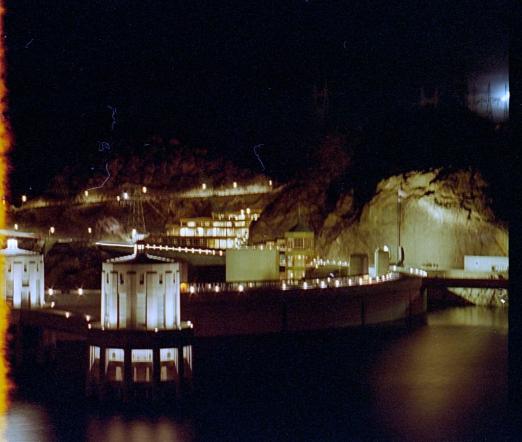
As we rode into the top of the valley, the lights that beamed from the dam announced its presence. At first I didn’t even recognize it — all the pictures and films I had seen before were taken during the day. In the valley, the only lights came from the dam itself. There were no spotlights, just a few bright lamps. The walls of the canyon were black, the reservoir was black, both were utterly featureless. As the road bent towards the eastern end of the dam, a small paved area formed to allow cars to stop. Stefan and I pulled out to take a look.
I was mostly interested in a picture. I had wound in the film I had bought at the Grand Canyon, but had neglected to wind it properly. I didn’t notice this error until after the pictures were developed — about a quarter of the frame had light exposure damage. But the rest of the time lapse shot gave me a memory of the Hoover Dam at night. Stefan noted that there was a security car parked nearby, the guards watching our every move. For a brief moment I felt like a terrorist planning the ultimate Coup de Gras.
Dhar awoke briefly as we started crossing the dam. He had no idea where we were until we told him that only 20 metres of concrete were preventing a lake from emptying itself and carrying us to certain death. Dhar urged me to drive a bit faster.
Visibility around the site was minimal for that time of night. All we could see were a couple structures: the four intake towers in the reservoir, a parking garage on the Nevada side and a tourist centre across the road from the parking garage. We happily noticed one bonus of crossing the border — we had another hour to get to Las Vegas, we had entered the Pacific Time Zone, the fourth zone in as many days. It was just after 01:00 Nevada time, and we still had 30 miles to Las Vegas.
The trip up the side of the canyon was slow, I was about as careful as when I had driven up to the Cave of the Winds. The primary difference here was that I couldn’t see must past the edge of the road. The greatest fear comes from not knowing … I didn’t know what (if anything) was down there, and I wasn’t too much in the mood to find out either.
Soon we were back in a 65 mile an hour zone traveling along Highway 93 towards downtown Las Vegas. The glow in the sky was so large by this point that we couldn’t tell where it ended. The spotlights from the Luxor were prominent — the four closely grouped bright spots were impossible to miss. As we rounded large hills, we could barely see the faint beam of light from the Luxor as it rose into the night.
Next thing I knew, we were blinded by a casino. Not just the sign of the casino, but the whole thing. I hadn’t seen that many lights before in my life in one place. I marveled at the sight. Stefan ho-hummed the casino, warning me that what I had just seen was nothing compared to what lay just beyond the hills surrounding the original “Sin City”.
And he wasn’t kidding. About ten minutes later, we reached the crest of those hills. The bleak black landscape dropped away revealing a glowing, pulsating being of light. The city was alive with itself. It was like nothing I had ever seen before.
In the summer of 1992 I was living in a house in Kanata, just outside of Ottawa. One of the occupants was a kindred student who had come from Acadia University in Nova Scotia to work for the summer. The largest city he had ever seen before was Halifax. With a population of only 115,000 people, Halifax is hardly the city that the Ottawa area creates. (The capital region has in excess of one million residents.) Driving eastward from Kanata along Highway 417 causes you to come over a rise, and at night the entire city and surrounding area glows with lights. My housemate thought the sight was impressive.
Ottawa barely holds a smoldering wick compared to Las Vegas on a foggy night let alone the dry, clear evening we crossed the hills.
Stefan and I immediately pulled the van over to the side of the highway and started rooting through the CD collection. I had planned in advance to bring some music that had the names of some of the places we would be visiting. Although I didn’t have the original Elvis version of the song, ZZ Top’s rendition of Viva Las Vegas, played at near-full volume, did as good a job. My skin tingled as we drove down the hill into the ocean of lights.
Dhar and Rebecca had to arise to the occasion, they really didn’t have much of a choice. The first order of business was finding out where the KOA was in relation to where we were. Stefan was desperate to take a quick tour of The Strip before turning in, and at first I honestly wanted to. But with every mile I kept driving, the more I wanted to stop and go to bed. Everyone else had slept, even if only a little. But I had been up for nearly 17 hours, most of that time on the road, and I was exhausted.
I had to let Stefan down on that. I really didn’t want to, but I was just too damn tired to really care at that point. We found the exit at Boulder Highway, and started heading south. Almost immediately an enormous sign for the Boulder Station loomed around. It cast so much light I felt the highlights on the Behemoth weren’t doing much good. About a mile down the road, we found the KOA.
We were justifiably surprised to find a guard booth about 20 metres from the road. Inside were two night guards watching TV and keeping an eye on the goings on about the campground. We pulled up and Stefan hopped out to get the arrangements of the night squared away. Although he actually got to talk with someone who seemed to know what was going on, it still took quite a while to fill out all the vital statistics (including the type of connection we wanted, the number of people in the van, the license plate, the colour, our average weight, height, sexual orientations, what mental state we were in, the amount of money we expected to lose at the casinos, and so forth).
Of all the KOAs we saw, Las Vegas was the most impressive. A large amount of money had been spent to create a beautiful park-like interior with well-paved roads, washrooms every 100 metres on each of the roads, all the amenities that even the most cushy motorhome traveler could need. Palm trees lined the roads, brilliantly coloured fragrant flowers were strategically placed to add to the beauty.
Our slot was right next to one of the washrooms, about 200 metres or so into the campground. Pulling in, I made quick work of hooking us up to the city utilities while the others made quick work of the toilets. It was already about 02:45 in the evening, but we weren’t anywhere near getting ready to go to bed. Unlike myself, the others were catching their second wind and wanted to see a casino as soon as possible. I contemplated not going and just going to sleep, but I remembered events that I had missed before on previous trips by going to bed … sleep be damned, I tagged along.
Las Vegas at night was absolutely awesome, to quote Dhar’s description. It was comfortably warm, the exact temperature at night where if it were one degree warmer or cooler, it wouldn’t feel right. But here it was perfect. There wasn’t a cloud in the sky … nor many stars for that matter — the city and casino lights were so bright that only the brightest shone through. The wind was but the slightest breeze, enough to remind me of some of my excursions to Florida in years past. Despite my exhaustion, it was too nice a night to sleep.
We wandered back out to Boulder Highway, which wasn’t a highway at all, just a large four-lane road, and walked about a half-mile or so to the Boulder Station. Even from the KOA driveway the sign was clearly visible, scrolling texts and all. The lights from the sign were almost as bright as day, taking pictures of it was a dead-easy task.
Rebecca turned towards the casino’s entrance wanting to see more. Remembering an episode of How’d They Do That? I suddenly realized that my camera could be a problem. Every casino in Las Vegas, or in the world for that matter, had security tighter than most top-secret government agencies. There was simply no way to cheat without the casino management from finding out. Every non-sanctioned device entering the casino could land you in some serious trouble. I saw no reason why my camera would be considered sanctioned.
Apprehension aside, we went in. Immediately we were confronted with slot machines, which probably collectively outnumbered the population of Nevada by a two to one ratio. The tones, tunes, and tings of the machines immediately caused my auditory system to overload, there was simply too much information to process. The experience is like living in a room where the light is always a soft white, then after 20 years you go into a disco. No, even that doesn’t quite cut it. It’s more like taking a very prudish, sexually repressed person and dragging them into a live sex show and placing them in the front row seat.
While my body tried to adjust to what I can only describe as culture shock, Dhar and Rebecca immediately sat down to try some video poker and slots. I had gone to Las Vegas with two ideas in mind: 1) Not to gamble at all, or 2) Spend $10 at the dollar slots and see what I could do. That night though, I wasn’t in any mental condition to do much else than observe the rest lose money.
Correction: I expected them to lose money. It seems however that Dhar has a horseshoe wedged up his ass — I haven’t seen someone that lucky in a long time. He would walk up to nickel slot, pop in no more than two nickels, and win at least six more. By the time we left he had increased a single nickel he borrowed from Stefan into about two to three dollars’ worth.
Rebecca wasn’t quite so lucky. She won a couple times, but the evening overall wasn’t too successful and she lost money. Stefan took his chances only once or twice, while I stood and watched the casino floor.
Never before had I seen such depravation. At somewhere around 03:00, there were still about a hundred or so people bent on winning money. As De Niro said in the movie Casino: “The longer you keep ’em, the more they lose.” When you bet small, as we did, that statement wasn’t quite true. But the people who were there at 03:00 with their large plastic cups of coins, the heavy smokers sitting around the card tables, and the anxious Keno players weren’t your average players, they were addicts.
There was a strange film that seemed to cover everything and everyone in that casino. All the employees seemed to have this dazed look about them, the patrons were blind, even the machines and tables looked slightly dingy. And the longer we stayed in there, the more I felt the same scum beginning to form on us.
I thought that the feeling was just the casino, but I soon realized that it was the city. Lasvegasitis … gamblemania … autogreedatory response … call it what you will, the disease is unmistakable and it afflicts everyone in time. The first symptom is a slight aversion to the atmosphere of Las Vegas. The second symptom is the most dangerous: acceptance. The third is a desire to gamble, and is the most subtle of the symptoms. Without treatment, this often leads to the full-blown virus that causes you to lose sense of time, and your money.
This was our first exposure, and we fortunately decided to cut it short before we got totally hooked. We continued to wander about the casino until we found a Dunkin’ Donuts shop that was still open. I guess the die-hard gambler needs a caffeine and sugar fix every so often. The others stocked up on coffee and sweets while I watched. My body was sending me signals ordering me to bed. Eating a donut at the time would’ve caused a revolt that I wasn’t in the mood for at the time.
Finishing the repast, we headed for the casino door and emerged into the comforting night. We crossed the immense parking lot surrounding the establishment, watching the security vehicles do their rounds. Reaching a gas station, Stefan and Dhar starting looking for the “magazines”. There were none to be found that night.
The last time Stefan had been to Las Vegas, he had seen a magazine that advertised all the prostitutes in the area. I’m an open-minded person, but when I heard about this I was a little shocked. I think that strip bars are degrading towards women, and you don’t want to know what I think of prostitution. The fact that Nevada had no laws against it was a curiousity to me, but the existence of such a magazine was nothing short of exploitation.
Upon returning to the van, the Captain Morgan’s came out of hiding. The only mixed drink I have ever had was a pseudo-screwdriver make with Five-Alive instead of orange juice. At the time I was already rather inebriated and really didn’t care what I was drinking. Here I was just too damn tired to do anything, let alone drink. The last of the Coke disappeared that night.
We sat out at the picnic table next to our van and began to talk about anything that came to mind. But no matter how hard I tried to concentrate, my mind kept wandering to thoughts of slumber. After ten minutes I gave up on the struggle and announced I was going to bed.
Although the night was warm, sleeping in a sleeping bag would’ve been too warm. The 110 volt air conditioner received its first trial that evening. I barely managed to get a log entry in before falling asleep.
Observer’s Log: Second Supplementary
I have seen the face of depraved greed and despair. Thy name is Las Vegas. Inspiring as it was to arrive with ZZ Top blaring, nothing could prepare me for what I saw, or what I’ll soon see.